You may have heard of the Great River Road along the Mississippi River. Rivers, like roads, are useful for transportation. The Mississippi river represents a very long and very wide river road from St. Paul, Minnesota to New Orleans, Louisiana. The river, however, can be temperamental. Of course, rivers don't have emotions, but high flood or low water could make great difficulties in navigating goods on the Mississippi. Some people hatched an idea to fix this; they wanted a reliable 9 foot navigation channel.
The Chain of Rocks area is called this due to some quirks of geology. During a period of glaciation, the Missouri River changed course. The old path was some distance into what is now Illinois. The new, and current path, cut over hard limestone which created ridges and shelves of rock that make navigation tricky. The river, at this point, looked like a chain of rocks at low water.
To solve this navigation problem, the Chain of Rocks Canal was cut through Illinois in the 1940s for a length of 8.4 miles. The chain of rocks, the namesake of this area, are now usually submerged under water except for times of extreme low water due to a dam put in place to ensure the Chain of Rocks Canal had sufficient water.
The Chain of Rocks Bridge, built in 1929 predates the cutting of the Canal by the Army Corps of Engineers. This bridge possesses a strange feature in that it takes a 22 degree turn along the way. This turn was a compromise between putting the supporting foundation of the bridge on firm ground and enabling fee access down the river in the years before the Canal was built.
In 1967, Interstate 270 opened and the Old Chain of Rocks Bridge was retired. In languished in disuse for a while and developed a bad reputation for crime. Fortunately, Trailnet reopened the Old Chain of Rocks Bridge for pedestrian and bicycle traffic in 1999. From this location or while driving across Interstate 270 just north of the old bridge, you can see two 'castles' sitting in the river.
A brief video clip from KSDK.com Goes into the towers and explains them.
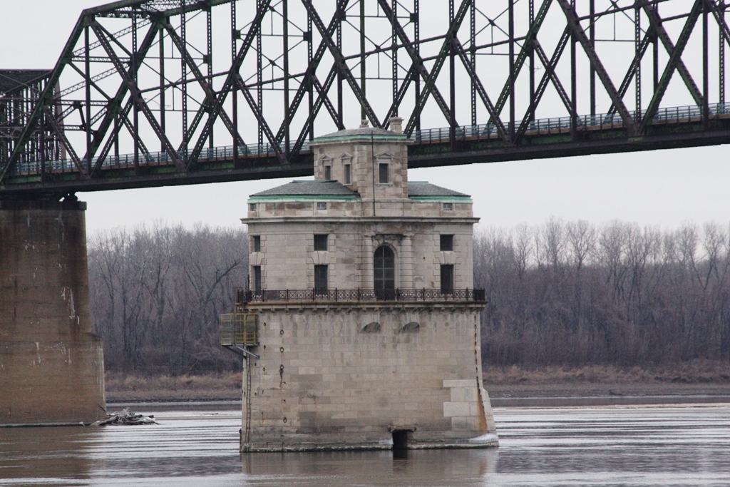 |
| "Water Intake CoRB" by Original uploader was Rklawton at en.wikipedia - Transferred from en.wikipedia; transferred to Commons by User:Xnatedawgx using CommonsHelper.. Licensed under Creative Commons Attribution-Share Alike 3.0 via Wikimedia Commons - http://commons.wikimedia.org/wiki/File:Water_Intake_CoRB.JPG#mediaviewer/File:Water_Intake_CoRB.JPG |
These were water intake towers and were once a source of pride. Fresh and clean drinking water seems like a simple thing for us in this modern age. Not always so. "This was built in the time when having good drinking water, safe drinking water was something that the citizens bragged about and not all cities had it," -- Curt Skouby, Water Commissioner
Related to the delivery of water to the City of St. Louis are the various "towers" found throughout the city. One of these in the Compton Hill Water Tower. These were standing pipes of water that helped regulate water pressure in the days when steam power was used to push water to the citizens. Improvements have taken these land-locked towers out of use, but you can still visit the Compton Hill Water Tower and enjoy a nice view if you have good lungs and strong legs. If you wish to attempt such a climb, further details can be found on the Water Tower and Park Preservation Society's website.
Related to the delivery of water to the City of St. Louis are the various "towers" found throughout the city. One of these in the Compton Hill Water Tower. These were standing pipes of water that helped regulate water pressure in the days when steam power was used to push water to the citizens. Improvements have taken these land-locked towers out of use, but you can still visit the Compton Hill Water Tower and enjoy a nice view if you have good lungs and strong legs. If you wish to attempt such a climb, further details can be found on the Water Tower and Park Preservation Society's website.
Some notes:
- Chain of Rocks Water Treatment Facilities
- Chain of Rocks Plant
- Sources
- Location:
- 11 miles north of downtown St. Louis
- 5 miles south of confluence of Missouri and Mississippi Rivers
- Named “Chain of Rocks” due to a large shoal or rocky rapids there.
- Because of a low-water dam built by Army Corps of Engineers, only visible in extreme low water now.
- Chain of Rocks Channel was cut in Illinois to avoid the Chain of Rocks Shoals.
- “In the late 1940s and early 1950s the U.S. Army Corps of Engineers built a 8.4-mile-long (13.5 km) canal to bypass this treacherous reach.” [Wikipedia: Chain of Rock Bridge]
- “The shoals were a severe navigational hazard, to the point that they were eventually bypassed entirely with the 8-mile-long Chain of Rocks Canal.” [Built St. Louis]
- Opened: 1894
- Purpose:
- Originally single channel water intake from Mississippi
- Water filtered and delivered to city.
- "This was built in the time when having good drinking water, safe drinking water was something that the citizens bragged about and not all cities had it," ~ Curt Skouby
- More reading: Further History
- Tower 1
- Sources
- Intake water tower No. 1 is closer to the Missouri side.
- Built in the early 1890s.
- Neither of the intake towers are in use these days.
- "They're similar in layout, but they're both unique," said Skouby.
- Tower 2
- Sources
- Closer to the Illinois side.
- Curt Skouby
- director of public utilities, the water commissioner
- "It was built between 1913 and 1915," ~ Curt Skouby
- "It was used as an intake tower to bring in water from the Mississippi into the Chain of Rocks." ~ Curt Skouby
- "This was built in the time when having good drinking water, safe drinking water was something that the citizens bragged about and not all cities had it," ~ Curt Skouby
- Someone was often here to operate the gates.
- Coal bin inside for heat.
- Neither of the intake towers are in use these days.
- "We get out here two times, maybe three times a year," ~ Curt Skouby
- Chain of Rocks Bridge
- Constructed in 1929
- Part of Route 66
- Financed by tolls.
- 1967, I-270 built
- Chain of Rocks Bridge closed
- 1981 “Escape From New York” filmed as 69th Street Bridge.
- Bad reputation for crime on closed bridge.
- 1999, bridge reopened for bicycle and pedestrian traffic.
- 22 degree turn
- Result of geologic shift in Mississippi River during glaciation.
- Old river bed lies to the east, in Illinois.
- Current river passes over resistant limestone.
- Bend was compromise
- Solid base for bridge.
- Access for river traffic.
Further Reading:
- Conor Watkins' Ozark Mountain Experience Article 4 Meet Me In St. Louis – Part II which disagrees with the video by implying the towers are still in use. Perhaps they were still in use when the article was written but have fallen out of use as indicated in the Video above.
- John Weeks III also provides a brief description of the Water Plant Intake Houses as well as a number of other articles under the heading of "Bridge Photography" and subheading of "St. Louis Area." These include one on the Chain of Rock Canal and another on the Chain of Rocks Bridge.
- Builtstlouis.net provides some of the same information but has their own set of pictures which are very nice to look at.
- Some more background can be gleaned on the Chain of Rock Bridge itself from the respective Wikipedia Entry.
- City of St. Louis Water Division's entry on The Chain of Rock Plant might also be of some interest, although it doesn't specifically mention the intake houses.
- Another tangentially related aspect of water supply in the City of St. Louis involves the Standpipe Water Towers that appear at various points in the city. The City of St. Louis Water Division also provides some information on this as well.
- The Water Tower Preservation Society provides a history page specific to these one of these Standpipe Water Towers, the Compton Hill Water Tower. If you have good lungs and strong legs, you might want to visit.
- The Compton Hill Water tower is a St. Louis Landmark.
- Water Intake Tower #1 is a St. Louis Landmark.
- Water Intake Tower #2 is another St. Louis Landmark. [2]
- The St. Louis Landmark site asserts Water Intake Tower #1 is still in use.
- Distilled History contains an article on the water towers.
- The Army Corps of Engineers has a PDF on the Chain of Rocks Lock and Dam
- Some details on the 9ft Channel and the Chain of Rocks Canal
No comments:
Post a Comment